
Thirteen districts in Bihar are on high alert after flood-hit Nepal released 10.5 lakh cusecs of water from the Kosi and Gandak barrages. Following this, embankment breaches were reported on Sunday (September 29) from several dams and rivers in the state, particularly impacting districts on the border with the neighbouring country.
According to officials, Bettiah, Motihari, Gopalganj, Saran, Muzaffarpur, Vaishali, Sitamarhi, Shivhar, Samastipur, Kishanganj, Araria, Purnia, Katihar, Supaul, Saharsa, Madhepura, Madhubani, Darbhanga, Khagaria, Bhagalpur, have been put on high alert. Despite some water levels receding in smaller rivers, the situation remains dire for more than 16 lakh people affected by flooding, with no fatalities reported so far, officials said.
#WATCH | Bihar: Several parts of Sitamarhi affected due to floods after the Mandar dam in Belsand Block of Sitamarhi district breaks (Earlier visuals) pic.twitter.com/4PhnPa2hO1
— ANI (@ANI) September 29, 2024
The Birpur barrage on Kosi River released 6.61 lakh cusecs of water, marking the highest discharge in 56 years. “This level of discharge is unprecedented, as the last recorded maximum was 7.88 lakh cusecs in 1968,” said the state water resources department (WRD).
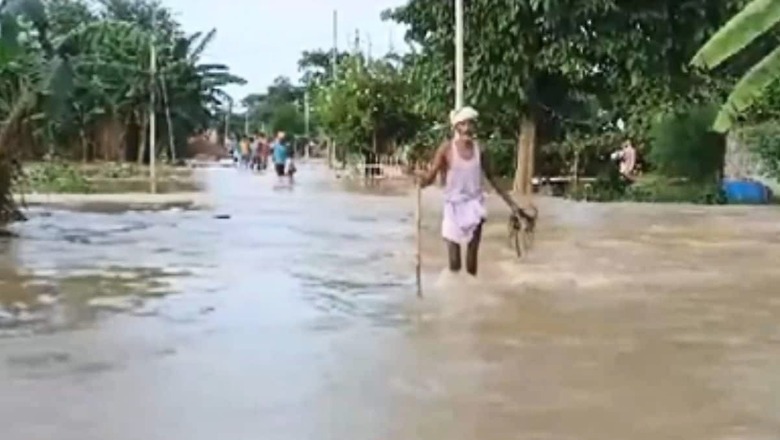
#WATCH | Bihar: Water of river Kosi has engulfed many northeastern districts of the state; normal life affected by floods-like situations in Supaul. pic.twitter.com/cSwzylNlWQ— ANI (@ANI) September 29, 2024
Similarly, Valmikinagar barrage on Gandak released 5.62 lakh cusecs, the highest since 2003. As a precaution, traffic near Kosi barrage has been halted to ensure public safety.
Following heavy discharge of water from these barrages, excess river water entered low-lying areas of West and East Champaran, Gopalganj, Araria, Supaul, Katihar, Purnea and several other districts.
#WATCH | Bihar: People of Araria district suffer as flood water enters houses due to a rise in water level in Pramana River. (28.09.24) pic.twitter.com/V5Lh4wQMIv— ANI (@ANI) September 29, 2024
Officials further said a breach occurred in the embankment of Bagmati River at Madhkaul village in Sitamarhi, while the Gandak river’s left bank embankment in West Champaran was damaged due to excessive water pressure, resulting in floodwaters entering the Valmiki Tiger Reserve.
“Due to the unexpected increase in the flow and water level of the Bagmati River, minor seepages on the left and right embankments in Belsand, Parsauni, Bargainia, and Rasalpur blocks of Sitamarhi district, as well as in Piprahi, Puranhiya, and Sheohar blocks of Sheohar district, were reported and immediately repaired,” the WRD said.
In response to the damage, Nishikant Kumar, executive engineer of the flood control division in Bagaha, was suspended for negligence and failure to coordinate effectively with local authorities. The department stressed on the seriousness of the situation, saying, “We are taking all necessary precautions to manage the flood risk.”
‘Rescue teams on alert, prepared for any eventuality’
Water resources minister Vijay Kumar Choudhary said teams are monitoring embankments on a 24-hour basis to respond swiftly to any erosion or danger. “There is nothing to panic about; our teams are always alert, and we are fully prepared for any eventuality, ” he told PTI.
He said incidents of water flowing above the embankments were also reported from Valmikinagar and Kiratpur in Darbhanga. “The water levels of Gandak, Kosi, Bagmati, Burhi Gandak, Kamla Balan and Mahananda, Bagmati and Ganga have has been rising across the state, following continuous rainfall over the past two-three days. Incessant rainfall in the catchment areas of Nepal has led to rivers touching or flowing above the danger level at several places in the bordering districts,” he added.
An alert has already been sounded for several districts as the IMD predicted heavy rain and warned of flash flood risk in parts of the state. Districts such as West and East Champaran, Sitamarhi, Sheohar, Muzaffarpur, Gopalganj, Siwan, Saran, Vaishali, Patna, Jehanabad, Madhubani and Bhojpur districts are likely to experience heavy rain.
“These districts are at risk of low to moderate flash floods,” the IMD said.
#WATCH | Bihar: Flood-like situation witnessed in Muzaffarpur as water enters Bakuchi Power Grid complex in Katra. pic.twitter.com/eY6jxZeFnC— ANI (@ANI) September 30, 2024
Current water levels at various gauge sites indicate they are above danger marks, further emphasising the ongoing flood risks in the region. The water level at Jhanjharpur gauge site of Kamla Balan River is recorded at 52.10 metres, which is 2.10 metres above the danger mark, while Gowabari gauge site of the Lalbekia River has reached 72.70 metres, 1.55 metres above the danger mark.
In addition, Taiyabpur and Dhegraghat gauge sites of Mahananda River are at 66.81 metres and 37.22 metres, respectively, exceeding danger thresholds by 0.81 metres and 1.57 metres.
(With PTI inputs)


Comments
0 comment