views
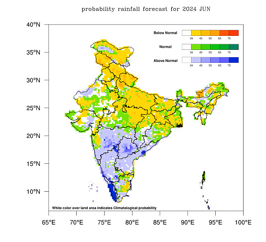
Hit by unusually long and severe heatwaves, India is expected to witness below-normal rains this June, said the India Meteorological Department (IMD) late on Tuesday. The weather department has revised its previous forecast of normal rains during the month after the southwest monsoon has slowed down its advance.
The rainfall is most likely to be less than 92 per cent of the Long Period Average (LPA) of 167 mm, said the IMD. The deficient rains are likely to exacerbate the oppressive heatwaves that have claimed several lives across the country. Maximum temperatures remain around 44-46℃ over northwest India with warm nights making the heat unbearable.

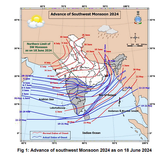
Despite an early onset over Kerala and the northeastern states on May 30, the southwest monsoon responsible for providing 70% of the annual rains over India has stagnated. It covered most of the southern peninsula and northeastern states normally by June 12 but turned sluggish after making onset over southern Odisha, Chhattisgarh, and sub-Himalayan West Bengal.

“Thereafter the monsoon has not progressed, and the northern limit of the monsoon continues to pass through Navsari (Maharashtra), Sukma (Chhattisgarh), Malkangiri (Odisha), Vizianagaram (coastal Andhra Pradesh), and Islampur (West Bengal),” said the IMD late on Tuesday.
It is yet to advance over Bihar and Jharkhand and cover the states of Odisha and West Bengal which are reeling under blistering heatwaves. The eastern states have been hard hit this summer with unusually long heatwaves that started as early as April. Normally, the monsoon should have reached Kolkata (West Bengal) by June 11, Gaya (Bihar) by June 16, and Varanasi (Uttar Pradesh) by June 20.
The IMD had earlier predicted normal rains for India in June at 92-108% of LPA and stated that it is likely to be below normal over many areas of northern and eastern parts of Northwest India and the eastern part of central India. But the actual rainfall deficit has turned out to be more than expected.
RAINFALL DEFICIT WIDENS OVER INDIA
As of June 18, India has only received 64.5 mm of rain, which is 20% less than its Long Period Average (LPA) of 80.6 mm. Northwest India, reeling under scorching heatwaves and warm nights, has faced the maximum shortfall – almost 70% below average. Except for some occasional thundershowers and dust storms, the rainfall has been scarce over the region where farmers are now preparing their fields for the summer crops. The rainfall deficit has widened to nearly 31% over central India and 15% over the eastern and northeastern states.
However, the southern peninsula has received 16% excess rains with the southwest monsoon in full swing since it made its onset over Kerala on May 30. The seasonal rains have already covered Kerala, Tamil Nadu, Karnataka, Telangana, Goa, Pondicherry, and major parts of Maharashtra and Andhra Pradesh. Region-wise, the rainfall is forecasted to be above normal over southern states.
WAIT GETS LONGER AS HEAT TAKES TOLL
The sluggish pace of the monsoon has raised worries over its timely advance over northwest India. Normally, it is expected to reach Delhi by June 27 and cover Punjab, Haryana, Chandigarh, and Uttar Pradesh by June 30. However, this time, it is yet to cover Bihar, Jharkhand and Chhattisgarh.
According to the IMD, conditions are expected to become favourable for the monsoon to cover the rest of Maharashtra, coastal Andhra Pradesh, and Odisha over the next 3-4 days, and advance over Chhattisgarh, some parts of Gangetic West Bengal and parts of Bihar and Jharkhand during the period. Normally, it should have already covered Bihar and Jharkhand by June 18.
The heatwave intensity is also expected to reduce over northwest India after June 19 due to some thunderstorm activity, but the temperatures are likely to rise again after June 23. The night temperatures have shot up and are at least 3-6℃ above normal. Varanasi (Uttar Pradesh) recorded the minimum temperature at 33.6℃ on Monday night – the highest in the last 55 years – while in Alwar it touched 37℃.


Comments
0 comment