views
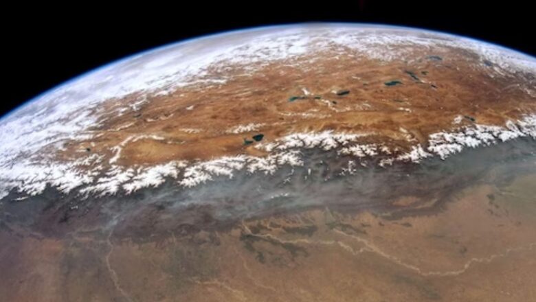
It is believed that there are two structures on Earth that are clearly visible from space, one is man-made and another, a marvel of nature. They are the Great Wall of China and the mighty Himalayan range. It is a marvel to see these pictures from space. Since not all of us can make it to space to experience the spectacular view, the International Space Station and NASA have our back. Photographs of the Indo-Gangetic plain, the Tibetan Plateau, and the Himalayas were taken by astronauts on board the International Space Station (ISS). Astronaut Don Pettit captured this expansive photograph in May 2012, showcasing a striking 600-mile (1000-kilometre) expanse of the Himalayan peaks covered in snow. The Tibetan Plateau’s many lakes and mountain glaciers can be seen beyond the mountains, while the Ganges/Ganga Plains are in the foreground. Over millions of years, the Ganges, Ghaghara, and Gandak — the three main rivers that flow through the plains — have carried enormous volumes of material from the Himalayas, much of which has been deposited in enormous alluvial fans.
The curve of Earth’s limb defines the horizon observed from orbit because of the oblique viewing angle from the International Space Station. The lens Pettit used (16 mm) is quite near to the focal length of the human eye (approximately 25 mm), therefore this photo view is close to the wonderful image that would have greeted his eyes that day. The highest mountain on Earth, Chomolungma/Mount Everest (8,848.86 metres or 29,031.7 ft), is unidentifiable to the unaided eye in this panoramic image.
You can see that light clouds are visible over Mount Everest. Monsoon clouds that could have brought rain did not arrive in the area at that time. Southern winds have guarded some major valleys of the Tibetan Plateau, causing clouds to appear upward. Another reason for the air being clean on this day was that the air pollution in this area was washed away by the winds.


Comments
0 comment